Guanahani
Inter-island track: MOS:INDIGENOUS
| ← Previous revision | Revision as of 10:07, 20 April 2026 | ||
| Line 50: | Line 50: | ||
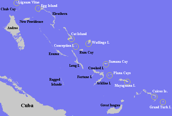
Besides the transatlantic track, the other important method for determining the location of Guanahani is the inter-island track, which can be traced either forward (from Guanahani to Cuba) or backward (from Cuba to Guanahani). Given the numerous descriptions of courses, distances, and directions in the log, this method seems more likely to pinpoint the location, and has been by far the method most frequently used by historians. |
Besides the transatlantic track, the other important method for determining the location of Guanahani is the inter-island track, which can be traced either forward (from Guanahani to Cuba) or backward (from Cuba to Guanahani). Given the numerous descriptions of courses, distances, and directions in the log, this method seems more likely to pinpoint the location, and has been by far the method most frequently used by historians. |
||
It was common practice among 20th-century historians to refer to the various Bahamian islands visited by Columbus by Roman numerals to avoid confusion: Island I being Guanahani, Island II being the second island visited by Columbus (which he named ''Santa María de la Concepción''); followed by Island III (named ''Fernandina'' by Columbus) and Island IV (called Samoete by the |
It was common practice among 20th-century historians to refer to the various Bahamian islands visited by Columbus by Roman numerals to avoid confusion: Island I being Guanahani, Island II being the second island visited by Columbus (which he named ''Santa María de la Concepción''); followed by Island III (named ''Fernandina'' by Columbus) and Island IV (called Samoete by the Indigenous inhabitants and renamed ''Isabela'' by Columbus). |
||
Following these four islands, Columbus next visited a string of seven or more islands in a line running north–south (which historians generally agree must be the modern [[Ragged Island, Bahamas]]) before landing on the north coast of Cuba. A successful inter-island track must therefore navigate from Guanahani to the Ragged Islands in a way that fits the descriptions of the log without serious infidelity. Strictly speaking this is impossible, as there are a few places where the log seems to contradict itself. |
Following these four islands, Columbus next visited a string of seven or more islands in a line running north–south (which historians generally agree must be the modern [[Ragged Island, Bahamas]]) before landing on the north coast of Cuba. A successful inter-island track must therefore navigate from Guanahani to the Ragged Islands in a way that fits the descriptions of the log without serious infidelity. Strictly speaking this is impossible, as there are a few places where the log seems to contradict itself. |
||


